The address-level risk platform

282.9M U.S. addresses, graded for risk.

Three data products, one platform. Atlas United grades every U.S. address across 54 perils. AtlasCast forecasts 10 storm perils to each one, refreshed four times a day. TrueFixR storm data shows where damage has already hit. The risk a property carries, the storm coming for it, and what it left behind.

54 perils · 10 live storm types · 16-day forecast · 282.9M addresses
Atlas data feed — UTC refresh 30s · methodology validated
/v1/risks/fast47msp95 24h cache hit99.94%edge throughput12,847 req/speak 60s addresses indexed282,904,029graph nodes convective cycle14ZT+18m fresh forecast run12Z16-day fwd radar scan14:30Z2-min cadence convective outlookENHTX · OK · KS tornado watches3active wildfire incidents471.2M ac YTD air-quality index152ABQ · USG flood layerv2024.2refreshed 12d seismic shakenightly02:14Z perils modeled54all major classes SFHA addresses5,389,072addrs · 2.45% model SLA99.97%trailing 90d
How it works

Address in. Audit-ready score out.

Our deterministic peril model spans 282.9 million addresses across 54 perils, calibrated against two decades of observed severe events and a sixteen-day forward layer. Every score is timestamped, versioned, and accompanied by a reason code — patent claim 30, USPTO 64/070,786 — built to survive regulatory examination.

01 · Address

Submit any U.S. address or parcel

Single call, batch CSV, or streaming. Rooftop geocoding plus parcel-shape resolution where assessor records exist.

1242 Ocean Dr, Miami, FL 33139
02 · Resolve

Cross-reference the hazard catalog

Fifty-four peril layers, climate normals, and historical events. Each value is timestamped, versioned, and cached to a parcel hash.

HURRICANE FLOOD WILDFIRE SEISMIC HAIL TORNADO SURGE +18
03 · Score

Return a graded peril profile

Letter grade, percentile rank, top contributing perils, and full methodology trace — all in one sub-200ms response.

F 98th %ILE
Miami Beach parcel HURRICANE · COASTAL FLOOD · STORM SURGE
0M
U.S. addresses graded across the lower 48 plus AK and HI.
0
Distinct perils modeled — flood, fire, wind, seismic, climate-chronic.
0 yr
Of validated severe-event observations in the calibration catalog.
0ms
Cold p95 API latency on /v1/risks/fast — single-PK lookup at carrier scale.
Capabilities

Fifty-four perils, one schema.

From acute hurricane risk to chronic heat-stress trajectories, every peril is normalized to a 0–100 percentile and an A–F grade with full methodology trace.

Hurricane
Coverage100% Atl. coast
Wildfire
WUI parcels44.8M
Flood (riverine)
SFHA layerLive
Storm surge
Surge zonesAll Cat 1–5
Tornado
EF tracks1950–today
Hail
Convective22-yr archive
Earthquake
Seismic hazard50-state
Heat stress
Chronic2050 horizon
See all 54 perils
AtlasCast · Live forecasting

Atlas United grades the risk. AtlasCast forecasts the storm.

Static grades tell you what a property is. AtlasCast tells you what's coming — a live, per-address severe-weather forecast built on federal weather models, refreshed around the clock.

  • 10 storm perilsTornado, hail, wind, flash flood, heavy rain, winter, ice, wildfire, hurricane and coastal surge — each with its own trained model.
  • Per addressScored against 282.9M U.S. address points, with modeled likelihood, severity and a reason on every lead — plus county grades and property value in the path.
  • 24h to 16dForecast windows from tomorrow to two weeks out, refreshed four times a day.
  • Federal dataBuilt entirely on first-party U.S. government weather models. No third-party feeds.
TornadoHailWindFlash floodHeavy rainWinterIceWildfireHurricaneCoastal surge
AtlasCast · Continental USForecast · refreshed 4×/day
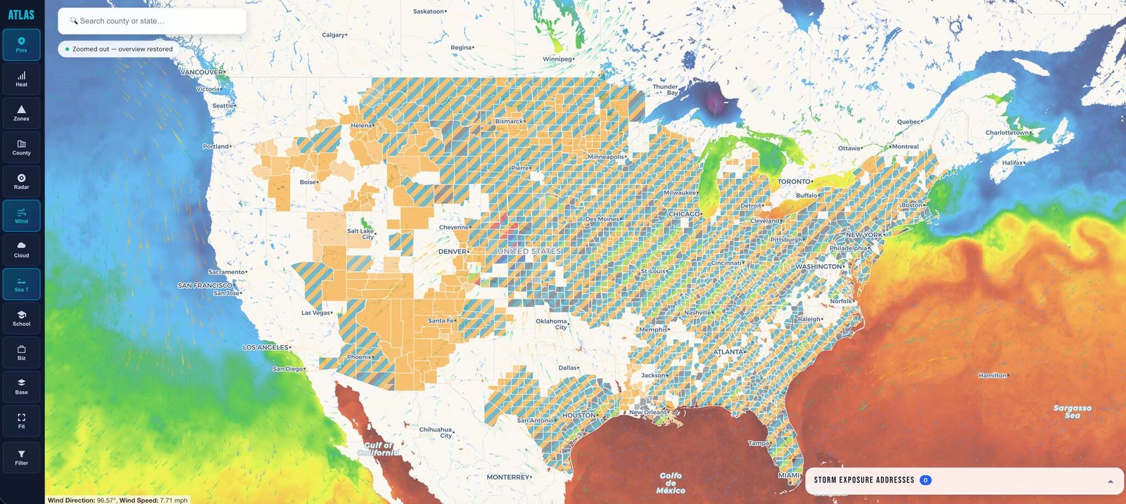
AtlasCast live national severe-weather forecast map
Data products

Three data sets. One platform.

Grades tell you what a property is. AtlasCast tells you what's coming. TrueFixR storm data tells you what already hit. Use one, or all three through the same API.

01 · What a property is

Atlas peril grades

A deterministic A–F grade and 0–100 percentile for every address across 54 perils, with the model version and methodology trace on every response.

  • 54 perils, one schema
  • Flood, wind, fire, seismic, chronic climate
  • Rate-filing-ready provenance
Property risk API
02 · What’s coming

AtlasCast storm forecast

Trained machine-learning forecasts for 10 storm perils, scored against 282.9M U.S. address points and refreshed four times a day from NOAA weather models.

  • Tornado, hail, wind, flash flood, heavy rain, winter, ice, wildfire, hurricane, coastal surge
  • Modeled likelihood, severity and reason per address
  • County grades, plus property value and people in the path
  • 24-hour to 16-day forecast windows
See the live map
03 · What already hit

TrueFixR storm data

Address-level storm-damage leads and event history, built for roofers, restoration crews, adjusters and emergency management offices that want the data itself.

  • Damage leads by county or state, up to 365 days back
  • Radar-reported hail history back to Nov 2019 (bulk)
  • Peril breakdowns and flood-risk context
  • 13-endpoint JSON API, one bearer token
Storm data API
10
storm perils with their own trained model
4×/day
forecast refresh, 03, 09, 15 and 21 UTC
~2M
address-level forecast leads per cycle
3,100+
counties graded, with exposure totals
Industries

Built for the balance sheet, not the demo reel.

Atlas United is engineered for the workflows that actually price and accept risk: actuarial, underwriting, accumulation management, and public-program design.

Methodology

Eight model layers. One unified grade.

Atlas United is a purpose-built deterministic peril model. Each layer is independently calibrated against decades of observed events and folded into a single audit-ready grade per address — no black-box blending, no proprietary aggregator math.

ATMOSAtmospheric & tropicalHurricane · Climatev2024.3
SURFACERiverine & coastal floodSFHA · Surgev2024.2
SEISMICEarthquake & tsunami50-state hazard2023 catalog
WILDFIREBurn & WUI exposureWUI · Embersv2024.1
CONVECTIVEHail · tornado · severe wind22-yr archive1950–today
CHRONICHeat · drought · sea-level2030 · 2050 · 2100Climate normals
HISTORICALValidated event catalog22 years · all perilsCalibration set
FORECASTForward probability layer16-day horizonSub-hour refresh
Read the full methodology
Compare

Why teams move off legacy vendors.

Legacy stacks were built when peril modeling meant licensing one vendor's black box and trusting the output. Atlas United is a transparent deterministic model with per-field methodology trace — designed for the way underwriters and regulators actually work.

Atlas United Verisk / AIR Cotality First Street
Transparent methodology ✓ Per-field Vendor docs Vendor docs
Cited provenance per score ✓ Per-field Vendor docs Vendor docs Partial
Sub-200 ms address API ✓ p50 ~10 ms Batch only Available
All 54 perils, one schema Fragmented Fragmented 5 perils
Federal-source citation per response ✓ Per-field No No Methodology PDF
Per-call pricing, no seat fees License License Tiered
See full comparison
"
A peril score that ships with the model version, the calibration vintage, and a cryptographic receipt. The methodology is the product.
Atlas United founder note
Get started

The peril stack your regulators already trust.

30-day evaluation with API keys, sample data for your book, and a deployment engineer assigned to your account.

0M U.S. addresses indexed across 54 perils
0yr Validated event catalog calibrating the model
0ms Cold p50 latency on the fast endpoint